Reading time:
Last updated:
September 28, 2026
Every campaign with a physical footprint has to answer a geographic question. Which areas should this budget cover?
The usual answer is whatever geography the planning tool offers. Postal codes, administrative regions, metropolitan areas, or a radius drawn around each location. All four are convenient, and none of them describe how people actually use a place.
That gap is one of the quieter sources of waste in local and regional media, because a plan built on the wrong boundary looks entirely reasonable on a map.
THE PROBLEM WITH ADMINISTRATIVE GEOGRAPHY
Postal codes exist to route mail. Administrative regions exist for governance. Metropolitan definitions exist for statistical reporting.
None were drawn with retail catchment in mind, and there is no reason they would align with it. A single postal code can span a dense commercial centre and a residential area whose occupants shop somewhere else entirely. A regional boundary can cut a natural catchment in half, or bundle together two towns that share no commercial relationship.
Using them is not wrong so much as arbitrary. The plan inherits a set of lines drawn for another purpose, then treats them as though they describe customer behaviour.
THE RADIUS PROBLEM
The standard alternative is a radius around each location, and it fails for a different reason.
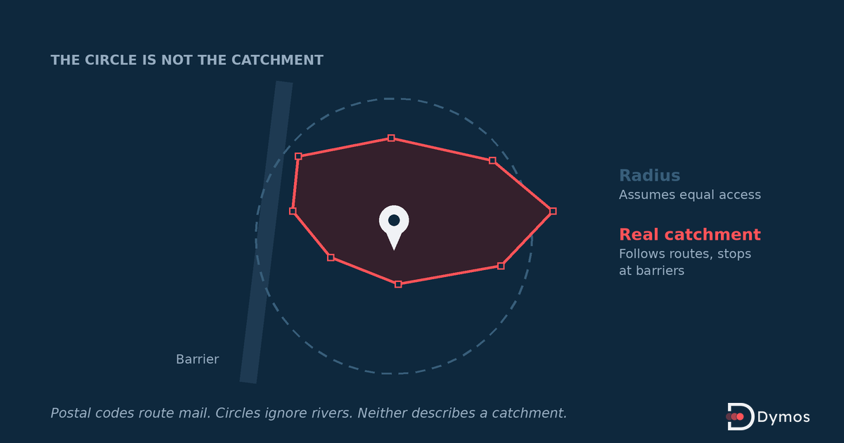
A circle assumes people approach from all directions equally, which they almost never do. A motorway on one side of a site, a river with no crossing, a railway line, a mountain, or a national border all distort the shape of a real catchment, sometimes severely. A store on the edge of a coastline has half its radius in water.
Drive time is a substantial improvement on distance, because it follows the road network rather than ignoring it, and a ten minute drive-time boundary is usually a far better approximation than a five kilometre circle. It still assumes people travel to their nearest option, which competition regularly disproves.
WHAT A REAL TRADE AREA LOOKS LIKE
Real catchments are irregular. They stretch along transport corridors, stop at barriers, and get pushed back where a competitor sits between a location and its potential customers.
They also overlap, which matters more than most plans acknowledge. Two locations belonging to the same business often share a substantial area, and a media plan treating each as independent buys the shared area twice. The result is inflated frequency in the overlap and underinvestment at the edges.
And they differ by purpose. The area a business draws from for a weekly shop and the area it draws from for a destination purchase are not the same shape, so a single boundary cannot serve both campaigns well.
URBAN AND RURAL ARE NOT COMPARABLE
The same boundary means completely different things in different settings.
A two kilometre radius in a dense city can contain a very large population with many competing options, meaning the boundary is generous and the competition intense. The same two kilometres in a rural area may contain few people and no alternatives, meaning the boundary is too tight and the catchment extends much further.
Applying one radius across a national network of locations therefore produces systematic over-investment in some places and under-investment in others, and the reporting will not reveal which is which unless someone looks.
THE EUROPEAN COMPLICATION
Cross-border catchments are a normal feature of European markets and a frequent blind spot in planning.
Locations near a national border often draw substantial custom from the other side, and administrative geography stops precisely where the commercial relationship continues. Country-level planning misses this by construction, and a boundary drawn to follow the actual catchment can look wrong to anyone reviewing a plan organised by country.
Language regions, commuter flows between neighbouring countries, and differing retail landscapes on either side of a border all compound the effect.
HOW TO DEFINE A BOUNDARY PROPERLY
Start from how people move rather than from what the map offers. Transport corridors, barriers, and competing locations shape a catchment more than distance does.
Use drive time in preference to radius wherever the tool supports it, and adjust it locally rather than applying one figure nationally.
Handle overlap deliberately. Decide whether adjacent locations should share an area or split it, and build the boundaries so the plan does not pay twice for the same households.
Vary the boundary by campaign objective, since a proximity-driven message and a destination message need different areas.
And revisit boundaries when the commercial landscape changes. A competitor opening between a site and its catchment changes the shape, and a boundary set three years ago may no longer describe anything real.
WHAT CHANGES IN THE MEDIA PLAN
Better boundaries do not usually increase spend. They redistribute it.
Budget moves out of areas that were included because a postal code happened to extend there, and into areas that were excluded because a circle stopped short of a corridor people actually travel along. Frequency in overlapping areas comes down. Coverage at the productive edges goes up.
The effect is most pronounced for businesses with many locations, because small errors repeated across a network compound into a large one, and least pronounced for single-site campaigns where someone local has usually already corrected the map by hand.
Frequently asked questions
FREQUENTLY ASKED QUESTIONS
What is a trade area?
The geographic area from which a location draws its customers. It is rarely circular and rarely matches administrative boundaries, because it is shaped by transport routes, physical barriers, and competing locations.
What is a custom polygon in audience targeting?
A boundary drawn to match a specific area rather than selected from standard regions. It allows a campaign to follow a real catchment, including irregular shapes that postal codes or radii cannot express.
Why not just use postal codes?
Postal codes are designed for mail delivery, not for describing commercial catchments. A single code can cover areas whose residents shop in entirely different places, and code boundaries frequently cut through natural catchments.
Is drive time better than radius?
Usually yes, because it follows the road network rather than assuming equal access in all directions. It still assumes people choose their nearest option, which competition often contradicts, so it is an improvement rather than a complete answer.
How should overlapping catchments be handled?
Deliberately. Where two locations of the same business share an area, a plan treating them independently buys that area twice, producing excess frequency in the overlap and thin coverage at the edges. Decide in advance whether to share or split.
Does the right boundary differ between urban and rural areas?
Yes. The same radius contains very different populations and very different competitive intensity in each, so applying a single national figure over-invests in some locations and under-invests in others.